


Coal River Mountain Slideshow
Coal River Mountain Slideshow
Monday, August 13th, 2007
Rising high above the Coal River Valley in Raleigh County, West Virginia, Coal River Mountain is one of the most beautiful and wild areas left in the coalfields. There has been little surface mining on the mountain to date and no mountaintop removal operations, however, subsidiaries of Massey Energy Company are proposing or planning almost 6,000 acres of surface mining on Coal River Mountain. If permitted this mine would destroy the tallest peaks that have ever been surface mined in West Virginia.
Coal River Mountain has become ground zero in the fight between proponents of large-scale surface mining in Appalachia and community groups working to end mountaintop removal and promote an alternative economic and energy production model in the “Coalfields.”
For a more in-depth slide show, check out our Flikr feed.

Coalfield residents who oppose mountaintop removal have long wished that wind energy production could replace the destructive mining practices that are destroying their communities. However, publicly-available maps of wind resources have typically shown little potential for wind development in the coalfields.
Shown in the image to the right are the results of a coarse-scale wind modeling project for 11 counties in Southern conducted by the wind energy consulting firm Windlogics. Typical of other large-scale wind studies, there would appear to be few, if any, economically developable wind sites in the coalfields. Based on this model, there are no peaks or ridges that reach 7 m/s in average wind velocity (class 4 wind site) – a level commonly viewed as the minimum threshold for industrial-scale wind development.

In contrast to the lower resolution model, the high resolution model below, also produced by Windlogics, indicates that the ridges on Coal River Mountain have excellent potential for wind development. The tremendous difference between the results of the two models is due to the highly variable topography of the coalfields – the coarse scale models are more useful for coastal areas and plains, as they average over a large area (low resolution). This means that, in areas like the coalfields, the excellent wind potential on the ridgetops tends to be obscured if it is averaged with the low wind potential of the valleys.

The areas covered by three permits, the applications for two of which have already been received by the West Virginia Department of Environmental Protection, would level more than 5,700 acres of Coal River Mountain, including nearly 3/4 of the area with good to excellent wind potential.

Based on an average capacity factor of 40% for 229 potential sites, estimated by the Windlogics model, a windfarm using the best ridges on the mountain could produce enough electricity to power 91,180 homes.
Given the controversial nature of wind farms elsewhere in Appalachia, the one major coal industry development on the mountain, the Brushy Fork Sludge Impoundment – the largest sludge dam in Appalachia holding back 8.1 billion gallons of coal sludge – provides an interesting contrast from the perspective of the people living below the mountain. Almost anybody would prefer to live near wind turbines than beneath a massive mountaintop removal operation or sludge dam and the local community appears to be far more favorable to a wind proposal than to the proposed mine permits.

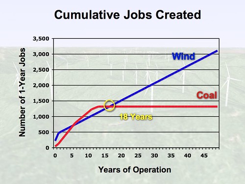
After just 18 years, an industrial wind farm would create more jobs (as measured in 1-year increments) than all three proposed surface mines combined and would continue to provide a steady source of employment for local workers indefinitely into the future. In just 86 years, this wind farm would create as much electricity as burning all of the coal that is expected to be produced from the proposed mines.
As of 2003 many nearby mountains had been leveled by mountaintop removal and the last 4 years have brought an accelerated pace of mining. Coal River Mountain is quickly becoming an oasis of wind power potential in a largely flattened area.

In addition to an expansion of the nearby mine sites, here is the future of Coal River Mountain as envisioned by the coal companies. The land disturbance shown on Coal River Mountain is a simulation based on the proposed boundaries of the Bee Tree, Eagle 2 and Eagle 3 permits.


October 30th, 2007 at 7:00 pm
Great display of info! Would you please supply the height above ground level at which Windlogics’ wind class estimates are based? The “high resolution” wind class estimates for the Coal River Mountain map (3rd from top) may only be applicable at heights that are from 50 to 100 meters above ground level.
Also, how many tons of coal are estimated to be mined from the 6,000 acres of Coal River Mountain which Massey’s subsidiaries are targetting? Is the coal tonnage estimate based on data found in their permit applications?
November 4th, 2007 at 9:37 pm
Is there a credible source for the “cumulative jobs created” claimed in the graph? The graph indicates that about 50 permanent (full-time) jobs will be created for a “wind farm” which has 229 wind turbines – approximately one permanent job for every 4 turbines. However, the wind industry’s average job rate is 1 full-time employee per 10 turbines (see current issue of North American Windpower). The lack of citations for source information about jobs creation of wind energy as well as other far-fetched claims (e.g., a 40% average capacity factor) does not bode well for the credibility of this research.
April 29th, 2013 at 12:27 pm
May God help us all. What are we leaving for our children and grandchildren? I am not sure they will even have water fit to drink, if we don’t leave nature alone….