


More Information
Reclamation FAIL Map
Our interactive online map shows the 500 mountains destroyed for coal and how they have been reclaimed- or not. It allows you to "fly down to the mine" to see "wrecklamation" for your self.
Press
You can read the official announcement on our press page.
Study details
Roughly 1.2 million acres, including 500 mountains, have been flattened by mountaintop removal coal mining in the central Appalachian region. Only a fraction of that land has been reclaimed for so-called beneficial economic uses.
These are the conculsions of two new studies from Appalachian Voices and the Natural Resources Defense Council that combine to debunk one of Big Coal's biggest lies. Below you will find more details about each study, and you can explore the data through our interactive Reclamation FAIL map.
Extent of Mountaintop Mining in Appalachia - 2009
Study Documents
![]() Area analysis detailed report (pdf)
Area analysis detailed report (pdf)
![]() Mountain count detailed report (pdf)
Mountain count detailed report (pdf)
Google Earth Layers
![]() 2006 mine boundaries (kmz)
2006 mine boundaries (kmz)
by Appalachian Voices
![]() 2007 mine boundaries (kmz)
2007 mine boundaries (kmz)
by SkyTruth
GIS Files
![]() 2006 mine boundaries (shp)
2006 mine boundaries (shp)
by Appalachian Voices
![]() 2007 mine boundaries (shp)
2007 mine boundaries (shp)
by SkyTruth
Authors
![]() 1. Ross Geredien
1. Ross Geredien
Environmental Consultant
2. Appalachian Voices
191 Howard St.
Boone, NC 28607
www.appvoices.org
With 95% accuracy, analysis shows that nearly 1.2 million acres (10% of Central Appalachia) have been surface-mined for coal. It also revealed that more than 500 mountains have been severely impacted or destroyed by mountaintop removal coal mining. The study was completed in 2009 by Appalachian Voices based on 2008 aerial and mining permit data.


Surface Mining "Reclamation" Survey - 2010
Study Documents
Google Earth Layers
GIS Files
Authors
1. Ross Geredien
Environmental Consultant
![]() 2. Natural Resources
2. Natural Resources
Defense Council
1200 New York Ave., NW
Suite 400
Washington, DC 20005
www.NoMoreMountaintopRemoval.org
Aerial imagery revealed that only a fraction of mountaintop removal mine sites are reclaimed for economic development projects. The vast majority of sites are in various stages of successional vegetation such as grassland, shrubland, tree plantings, or active mining.
Of the 410 reclaimed mountaintop removal mine sites surveyed, 366 (89.3%) had no form of verifiable post-mining development, excluding forestry and pasture.
The so-called beneficial development projects include: industrial parks (4); oil and gas fields (3); golf courses (3); airports (2); municipal parks (2); hospital (1); ATV training center (1); county fairground (1); federal prison (1). Commercial agriculture or farming was identified on nine sites, sometimes in conjunction with other land uses such as residential development. (The post-mining land use of 18 other sites remains uncertain.)
The post-mining land use status of all but 18 mountain locations was identified with a high level of confidence. These 18 locations were identified as having “possible” post- mining economic land uses. Frequently some evidence of potential economic reclamation existing on these sites, such as mowed fields or improved structures, but specific land use was not clear. In some cases, it was not clear whether structures were abandoned or directly connected to former or existing mining activity on site or nearby.
It is clear that mountaintop removal has not yet led to much economic development on reclaimed mine lands in Appalachia, nor is there a shortage of landscapes with flattened topography available for industrial, commercial, or residential post-mining economic development.
State |
"Reclaimed" |
"Reclaimed" |
"Reclaimed" |
Total mountains |
|
Kentucky |
248 |
10 (4%) |
8 (3%) |
293 |
|
Virginia |
60 |
12 (20%) |
4 (6.6%) |
66 |
|
West Virginia |
96 |
4 (4.2%) |
6 (6.3%) |
135 |
|
Tennessee |
6 |
0 (0%) |
0 (0%) |
6 |
|
Total |
410 |
26 (6.3%) |
18 (4.4%) |
500 |
|
Extent of Mountaintop Mining in Appalachia - 2012 Update
Resources
Google Earth Layers
![]() 2012-February mine boundaries, impoundment locations, processing plant locations (kmz)
2012-February mine boundaries, impoundment locations, processing plant locations (kmz)
NOTE: THIS IS THE MOST CURRENT REGIONAL EXTENT MAP AVAILABLE
Authors
1. Matt Wasson
Appalachian Voices
191 Howard St.
Boone, NC 28607
www.appvoices.org![]()
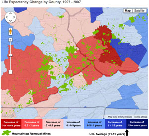
 In February 2012, the iLoveMountains.org team launched a startling interactive map: The Human Cost of Coal. It combines a myriad of health and economic statistics with our latest survey of the extent of mountaintop removal mining in Appalachia.
Appalachian Voices • Coal River Mountain Watch • Heartwood • Keeper of the Mountains • Kentuckians for the Commonwealth
Ohio Valley Environmental Coalition • Statewide Organizing for Community eMpowerment • Sierra Club Environmental Justice
Southern Appalachian Mountain Stewards • SouthWings • Stay Project • West Virginia Highlands Conservancy

Site produced by Appalachian Voices 589 West King St, Boone, NC 28607 ~ 1-877-APP-VOICE (277-8642) ~ ilm-webmaster@ilovemountains.org